


Socorro County Precinct 12, Socorro County, New Mexico
About
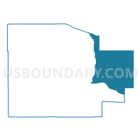
Outline

Summary
| Unique Area Identifier | 624195 |
| Name | Socorro County Precinct 12 |
| County | Socorro County |
| State | New Mexico |
| Area (square miles) | 1,003.91 |
| Land Area (square miles) | 1,003.91 |
| Water Area (square miles) | 0.00 |
| % of Land Area | 100.00 |
| % of Water Area | 0.00 |
| Latitude of the Internal Point | 34.05793010 |
| Longtitude of the Internal Point | -106.20618970 |
Maps


Graphs
Select a template below for downloading or customizing gragh for Socorro County Precinct 12, Socorro County, New Mexico


Neighbors
Neighoring Voting District (by Name) Neighboring Voting District on the Map
- Lincoln County Precinct 1, Lincoln County, NM
- Lincoln County Precinct 13, Lincoln County, NM
- Lincoln County Precinct 19, Lincoln County, NM
- Socorro County Precinct 11, Socorro County, NM
- Socorro County Precinct 16, Socorro County, NM
- Socorro County Precinct 22, Socorro County, NM
- Torrance County Precinct 10, Torrance County, NM
- Torrance County Precinct 8, Torrance County, NM
- Torrance County Precinct 9, Torrance County, NM
- Valencia County Precinct 29, Valencia County, NM
- Valencia County Precinct 30, Valencia County, NM
Top 10 Neighboring County Subdivision (by Population) Neighboring County Subdivision on the Map
- Belen CCD, Valencia County, NM (20,808)
- Socorro CCD, Socorro County, NM (14,354)
- Mountainair-Encino CCD, Torrance County, NM (2,294)
- Carrizozo CCD, Lincoln County, NM (1,423)
- Corona CCD, Lincoln County, NM (403)
- Claunch CCD, Socorro County, NM (97)
Top 10 Neighboring Unified School District (by Population) Neighboring Unified School District on the Map
- Belen Consolidated Schools, NM (30,853)
- Socorro Consolidated Schools, NM (12,352)
- Estancia Municipal Schools, NM (4,797)
- Mountainair Public Schools, NM (1,866)
- Carrizozo Municipal Schools, NM (1,534)
- Corona Municipal Schools, NM (452)
Top 10 Neighboring State Legislative District Lower Chamber (by Population) Neighboring State Legislative District Lower Chamber on the Map
- State House District 50, NM (31,808)
- State House District 49, NM (31,024)
- State House District 7, NM (29,350)
- State House District 57, NM (26,051)
Top 10 Neighboring State Legislative District Upper Chamber (by Population) Neighboring State Legislative District Upper Chamber on the Map
- State Senate District 30, NM (48,188)
- State Senate District 33, NM (45,419)
- State Senate District 28, NM (43,562)
- State Senate District 8, NM (40,059)
Top 10 Neighboring 111th Congressional District (by Population) Neighboring 111th Congressional District on the Map
Top 10 Neighboring Census Tract (by Population) Neighboring Census Tract on the Map
- Census Tract 9781, Socorro County, NM (4,253)
- Census Tract 9637, Torrance County, NM (2,294)
- Census Tract 9602, Lincoln County, NM (1,826)
- Census Tract 9711, Valencia County, NM (1,595)
Top 10 Neighboring 5-Digit ZIP Code Tabulation Area (by Population) Neighboring 5-Digit ZIP Code Tabulation Area on the Map
- 87002, NM (22,517)
- 87062, NM (1,869)
- 87036, NM (1,868)
- 88301, NM (1,386)
- 87832, NM (600)
- 87011, NM (84)